
Day one.
It feels great to be back on the Road to complete our tour of the South Island of New Zealand, after nine months at home. Last Summer we explored the lower regions of the South Island and now we will carry on exploring the upper regions.

Our first few days will be a slow shake down as we have arranged to spend the first weekend travelling in company with friends. A good opportunity to get back into the way of life aboard our motorhome and check all is in order to carry on with our journey.
We headed for the Canterbury High Country, Rakaia Lakes district and after a stop at Lake Georgina for fishing, we carried on to the Harper Village Camp site at the head of Lake Coleridge. Harper Village is a former Electricity Department staff camp which housed workers for the construction and maintenance of the diversion canals from the Harper and Wilberforce rivers. These canals carry water from these rivers to the head of Lake Coleridge to be used for power generation at the Lake Coleridge Power Station. The campsite is provided courtesy of Trustpower.


Day two.
The Harper Village road is not a through road, so we returned as far as Lake Coleridge High Country Station, stopping at Lake Selfe and Lake Georgina to fish in difficult windy conditions. Before leaving Lake Georgina we walked round the lake, weaving through the Matagouri and enjoying the mountain scenery.


From Lake Coleridge Station we took the gravel back road to Lake Lyndon for the night. Here we were greeted with a cold Southerly wind and single digit temperatures. Not what we expect in Summer and a stark contrast to the thirty plus degree days we have been experiencing over the last two weeks.
Day three.
A quiet day today, fishing and walking at Lake Lyndon surrounded by beautiful scenery and imposing mountains. We think the Canterbury alpine areas are an under appreciated asset, which we enjoy immensely when we regularly visit them.
Around the middle of the afternoon we made our way to or friends home in Kirwee for a BBQ and pleasant evening.

Day four.
Today we travelled in company with our friends from Kirwee and their Campervan to Motunau Beach, a small fishing and bach community on the North Canterbury coastline. Motunau Beach is one of our favourite local destinations and the place of countless memorable family holidays throughout my life. We stopped in Amberley on the way to inspect the local Saturday Farmers Market plus have coffee and food at the Paris Bakery Cafe, on the recommendation of a family member. Well worth the stop with excellent food and very good pies, 8/10. Arriving at Motunau Beach in a cold Southerly wind and rain, the rest of the day was quiet and convivial inside the vans, with a short walk during a break in the weather. Looking forward to the prospect of a fine day tomorrow and the first harvest of our travelling salad garden. Four lettuce plants growing in a container for the last month should provide us with fresh salads for a large portion of our tour.

Day five.
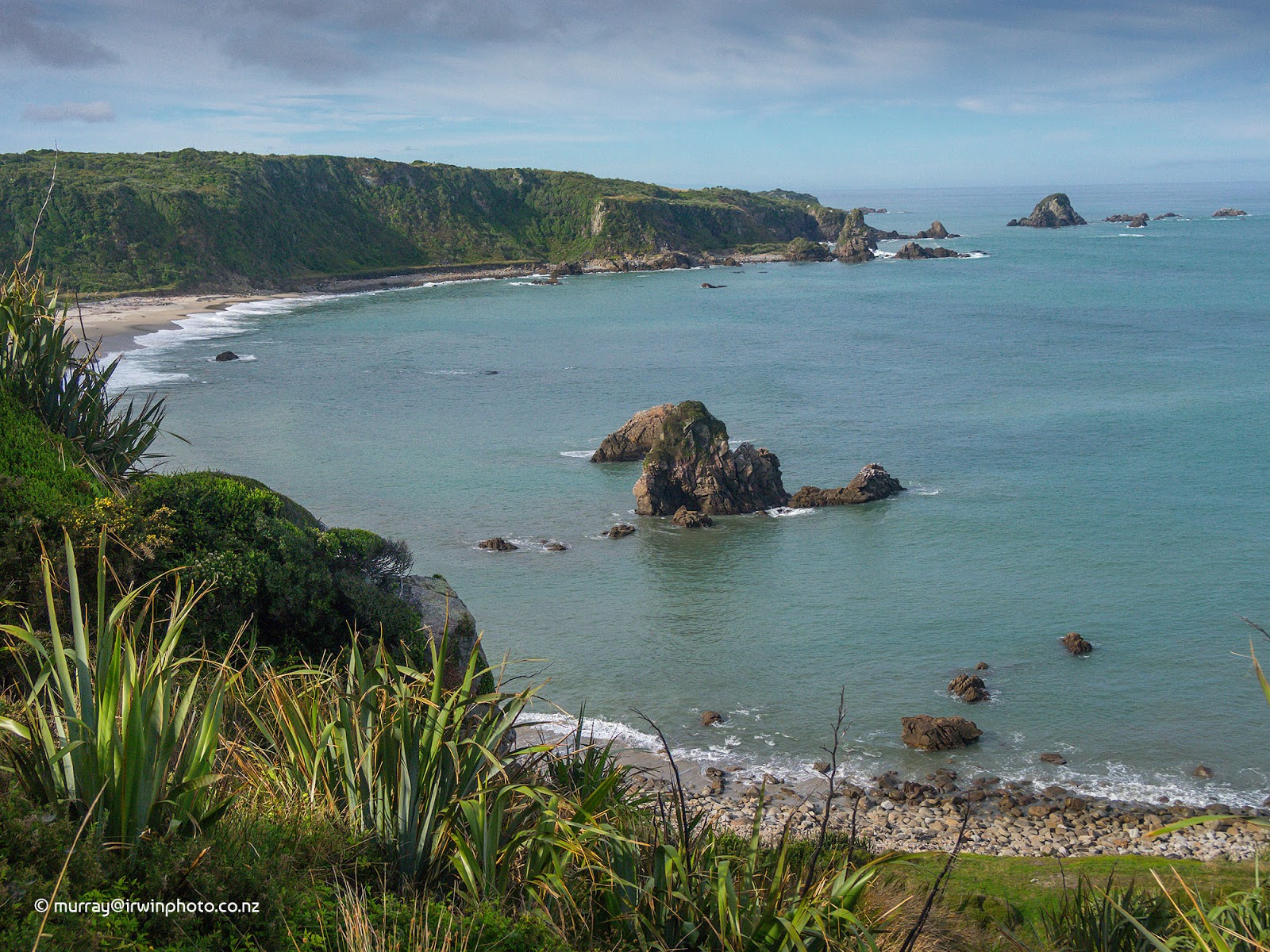
We awoke this morning to a clear still day with early sunshine rapidly warming the cool air. Breakfast complete we set off to explore the beaches of Motunau on foot. The view to seaward is dominated by Motunau Island 1.2 kilometres offshore. The island is restricted access by permit only and is a breeding sanctuary for a large number of animals including Little Blue Penguins and New Zealand Fur Seals.


Starting at Sandy Bay we walked south around the rocky headland and along the second beach for about three kilometres to a collection of concretion boulders similar to the Moeraki boulders.


While walking on the beaches we kept a lookout for marine fossils which are abundant here, often found in small concretion rocks. Between us we found several fossilised crabs and one fossil which appears to be a large shrimp.

A most enjoyable walk in stunning Summer weather with the midday low tide timed almost to perfection.


Later in the afternoon our friends, Graham and Jo, departed for their home in Kirwee while we travelled via Greta Valley, Scargill and Waikari to Hawarden in preparation for our next destination.
Day six.
Hawarden is a typical small New Zealand rural town with a Four Square grocery store where the locals gather to chat, a Domain with sports fields, a War Memorial Hall and an old Post Office building among other things.

We were under way by nine o'clock, bound once again for the Canterbury High Country at Lake Taylor. The drive to Lake Taylor includes 36 kilometres of rough, corrugated and dusty gravel road. But it is well worth the effort for the views of the Hurunui River and Gorge, with the Department of Conservation camp site on the shore of the lake being one of our favourites. From the end of the road at the camp site there is a four wheel drive track to Loch Katrine a further 8 kilometres, but too rough for our motorhome. A walk along the four wheel drive track and lake shore, fishing and swimming in the sub alpine lake filled the afternoon which reached 27 degrees.


Day seven.
We remained parked on the lake shore today relaxing and enjoying the scenery with changing light from dawn till dusk. Clear skies, sunshine and little wind pushed the temperature to 28 degrees necessitating more swimming to cool off.


Day eight.
Another crack at the elusive fish before packing up for the return trip down the dusty road with a freshening Nor'wester behind us. Hard to leave this behind.

A brief stop to view the rugged upper Hurunui River.


Our final destination for the day was Balmoral Reserve beside the Hurunui River, which here has changed to a typical Canterbury braided river flowing through the tinder dry Summer landscape. With the temperature reaching 30 degrees, cooling our feet in the river and looking for shade were our priorities.


Day nine.
Not much to report today except we relocated to Deer Valley DOC campsite, 3 kilometres east of Lewis Pass. We spent the night here at this compact little camp site amongst the Beech tree forest beside the Lewis river at about 800 metres above sea level.


Day ten.
Our destination for today was Reefton with a couple of stops along the way. First up was the top of the Lewis Pass where we walked for 45 minutes along the St James Walkway, Cannibal Gorge, to a large swing bridge across the Maruia River.


On returning to the start point, we completed the short Nature Walk loop where the lichen hangs on Beech trees like lace, and viewed the tarn complete with tadpoles and an eel.


Moving on to Marble Hill DOC camp site we did the five minute walk to a squeeze in the Maruia River called the 'Sluice Box Gorge'.


We then carried on our way to Reefton, the first town in New Zealand to have electric lighting. On the 4th of August 1888 Reefton became the first place in New Zealand and the Southern Hemisphere to have a public supply of electricity, even before the fashionable suburbs of London and New York.
Day eleven.
On with our boots today for a hike in the hills to the east of Reefton. Starting from Blacks Point we climbed rapidly up Murray Creek gully through lush Beech forest to view the mining sites and relics of the Murray Creek Goldfields Track.

The mine sites, all now abandoned, are high in the hills on steep terrain, well sign posted by DOC with information boards at each of the sites. It is astonishing the endeavours undertaken in the pursuit of gold, many of them unrewarded. The vertical mine shafts cut into the hills were hundreds of metres deep. Smaller horizontal mine shafts disappeared into the hillsides in many places.


At times we caught brief glimpses of the surrounding country through the thick forest growth, including the Waitahu River valley.

This walk was enjoyable, but after nearly four and a half hours and eleven and a half kilometres along tracks at times very steep, we were glad to be back at our motorhome.
After a quiet afternoon relaxing after our hike we moved west to Slab Hut Creek DOC campsite.
Day twelve.
Slab Hut Creek campsite is a public gold fossicking area where you can try your luck panning for gold in the creek without a prospecting licence, one of nineteen such areas in the South Island.

We are back to the tannin stained rivers, creeks and lakes of the West Coast, giving them their distinctive brown colour, leached from the leaf litter on the forest floor.


Travelling further west, passing through Ahaura with it's eye catching quirky Gallery, our stopping place for the night was Nelson Creek campsite. This lovely, well maintained and picturesque campsite is run by the local community.


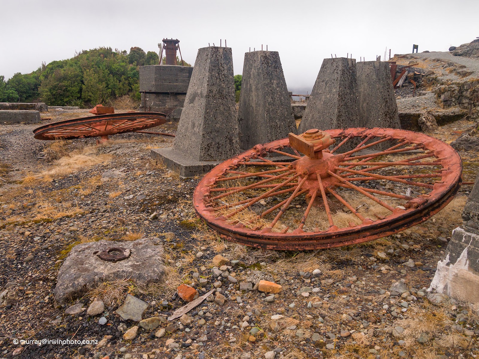
Nelson Creek was the site of one of the richest and longest lasting goldfields on the West Coast. Firstly worked by hand by early prospectors, then by sluicing once large quantities of water were chanelled to the site, some from Lake Hochstetter 30 kilometres away, and finally by gold dredges. Rusting gold dredge components can be seen at the camp site. From the campsite walking access to extensive water race and tail race diggings across Nelson Creek is possible by way of a historic tunnel and swing bridge. Many of these water races are barely half a metre wide but several metres deep.


Day thirteen.
More old stuff today.
Westland celebrates it's pioneering past very well with relics displayed, some restored, and memorials in many places. Most of them relating to the gold and coal mining past as well as the timber milling industry of years gone by. This bush locomotive near Ngahere which once hauled timber wagons has been preserved from a rusting derelict.

Old abandoned and weathering farm buildings are also a common site.

It had been raining periodically for a day or so as we left Nelson Creek intending to travel to the Moonlight Track carpark and the Grey River was flooded, turbulent and muddy as we crossed it. The road to the Moonlight Creek valley started quite reasonably but soon became narrow and rough, more like a creek bed in places. After several kilometres we encountered a bridge over Moonlight Creek. It became obvious that the rain had been falling heavily in the Paparoa Ranges as Moonlight Creek had become a raging torrent of muddy water not at all resembling a creek. Also there was a sign indicating our motorhome was too heavy to be supported by the Bailey bridge before us. Fortunately we were able to turn around.


Next, a visit to the historic coal mining town of Blackball best known as being the birth place of the New Zealand Labour Party, the home of the Blackball Salami Company and location of the 1910 (old) hotel 'Formerly the Blackball Hilton'.


From here we travelled north along the rugged coastline with rough sea conditions until we arrived at the freedom camping site at Tiromoana beside the Fox River mouth where the old road bridge is under restoration.


Day fourteen.
A wet and misty day today, on which we started by back tracking a little to the Pancake Rocks of Punakaiki. Despite the large swells driving on the shore, the blowholes were not performing as it was a little too long past the high tide. However, we have experienced the blowholes operating many times in the past.


Next stop was the Pororari River where we walked to the junction with the Inland Pack Track, about fifty minutes each way, which with the rain slowly increasing, saw us back to our motorhome a bit wet.


Back on our journey north, we arrived at our destination for the day of Okari Beach, south of Cape Foulwind.
Day fifteen.
Started today with a walk on Okari Beach in the sunshine.


Today's highlight was a cave rafting adventure Underworld Adventures, Charleston.
Starting with a bush train trip up the Nile River valley, we then descended into the labyrinth of tunnels and chambers formed in the limestone by ancient rivers. Stalactite and stalagmite formations are to be seen everywhere. Floating through the glow worm chambers was stunning. Finishing with a raft trip down the Nile River on our tubes. Absolutely brilliant and well beyond our expectations.


A visit to Constant Bay at Charleston and the beach at the mouth of the Nile River on our way back to Okari Beach for another night with our hosts. Enjoying the West Coast sunsets again.


Day sixteen.
Fine sunny weather gave us the opportunity to walk the Cape Foulwind lighthouse and New Zealand Fur Seal colony walkway. Wonderful views from mountains to sea all along the track plus an observation platform to watch seal pups playing in rock pools. We walked back to our hosts home along the beach of Tauranga Bay, a popular surfing beach.


Leaving Okari Beach we headed for Westport to restock our motorhome before continuing north to the Mokihinui River at Gentle Annie campground and the Cow Shed Cafe for the night.

Day seventeen.
Just a day for moving on today as strong winds and heavy rain were forcast. Our destination for a couple of days was Kohaihai DOC campground at the southern terminal of the Heaphy Track. Situated beside the Kohaihai River at the head of a wild windswept West Coast beach, it is a favourite of ours. The wind and rain were not as severe as forcast which allowed us to walk the short distance to the Nikau Palm Grove short walk. The Sandflies on the other hand were very severe. thankfully we refurbished our insect screens before leaving Christchurch.


Day eighteen.
Our second day at Kohaihai campground.
With rain forcast for the afternoon we laced our walking shoes on and hiked about an hour along the Heaphy Track to Scotts Beach. Wild and largely untouched, with a powerful surf running this beach is a special place, which photographs struggle to do justice to.


The forcast rain arrived in the afternoon, so the rest of the day was spent relaxing. The skies cleared in the evening to a colourful sunset.


Day nineteen.

Short walks today.
Started with The Big Rimu Tree walk in the Umere Valley beside the Karamea River.

Next was the walk into Lake Hanlon, very tranquil.

Finally we strolled one and a half kilometres along The Old Ghost Road track, up the Mokihinui River gorge to Welcome Creek.

We would have liked to visit the Oparara Arches but our vehicle is deemed unsuitable for the narrow winding shingle access road. We have been there many times before and would highly recommend visiting them. Back at Gentle Annie Campground on the banks of the Mokihinui River for the night.

Day twenty.
A fine sunny day at Gentle Annie campground beside the Mokihinui River mouth and pebble beach as we prepared to leave for Ngakawau.


Unfortunately our plan to walk the bottom half of the Charming Creek walkway up to the Mangatini Falls was not to be. Due to a serious landslide on the track in the lower gorge, the track was closed from the Ngakawau end. Only access from the Seddonville end of the track was possible. We have walked this track in it's entireity several times and highly recommend it. Hopefully it will be reopened soon.

Lunch was planned at the small roadside cafe at Waimangaroa, recommended to us by the locals, where the pies were exceptionally good (7.5/10).

Following lunch we drove 'up the hill' to the Denniston Plateau coalfields, six hundred metres above sea level. Here amongst the relics you can discover the history of New Zealands most prosperous coal company and the conditions endured by the inhabitants of this bleak environment. A major feature of Denniston was the infamous incline, claimed to have been the steepest railway in the world, used to get the coal down the hill to be railed to Westport.


Days end found us at Westport.
Day twenty one.
Westport to Murchison today, travelling up the beautiful Buller River gorge. One stop along the way at the historic site of Lyell township. Once a significant gold mining town of over two thousand people, nothing is now to be seen of the many buildings that once stood here. The Department of Conservation run a campsite here with several walks available to gold mining relics including quartz crushing batteries and equipment used to extract gold from quartz. We did a loop walk via the Lyell cemetery to the Croesus battery and returned along The Old Ghost Road, which starts at the Lyell campsite.


Day twenty two.
We left Murchison this morning with it's second hand stores and headed up the Matakitaki River valley to Six Mile.


There we walked the historic hydro power scheme track alongside the penstocks, the reservoir and water race to the weir which diverted water from Six Mile Creek to be utilised for electricity generation at the power house from 1922 until 1975. This one and a half hour walk turned out to be a real gem and thoroughly worth the effort of getting there.


We finished our day at Lake Rotoroa with a swim in the lake.

Day twenty three.
The fish weren't biting, but the sandflies were, so we left Lake Rotoroa.
After an unsuccessful attempt to reach Louis Creek Camping site in the Howard Valley, as the road became far too rough for our motorhome, we carried on to Lake Rotoiti.

Following a brief stop to take in the view, we continued on our way to Argyle Pond for the night and some fishing.
Day twenty four.
Argyle Pond is a reservoir for Trustpower's Argyle power generation scheme, which draws water from the Branch River via canals, to pass through two hydro power stations before being discharged into the Wairau River.


The pond and canals are stocked with trout for recreational sports fishers, one of which, a four pound Rainbow Trout obliged by hooking itself to my line before being released back into the pond.
Around midday we left Argyle Pond heading down the Wairau Valley which, dry and parched, presents a stark contrast to the last two weeks spent on the lush green, high rainfall West Coast.

But across the road, growing green in the Marlborough sunshine were grape vines, part of the many thousands of hectares for which this major wine producing area is famous.

Days end found us at Onamalutu Domain DOC campsite.
Day twenty five.
Onamalutu Domain is a DOC campground located in Mount Richmond Forest Park, set aside as a reserve in 1901 by sawmiller Charles White. It is an expansive grassed area surrounded by large Kahikatea and Matai trees, a remnant of the lowland podocarp forest which used to be found all over the Wairau Plain.

From here we proceeded to Picton to spend a few days with our long time friend, Ian.


No comments:
Post a Comment