Day one.
Following our guided Four Wheel Drive safari with NZ Adventures in November 2022, which we enjoyed immensely ,we promptly booked ourselves on another safari.
Congregating at eight o’clock in the morning of Friday November 15th 2024 for roll call and radio check we recognised some familiar faces from our first 4WD adventure.
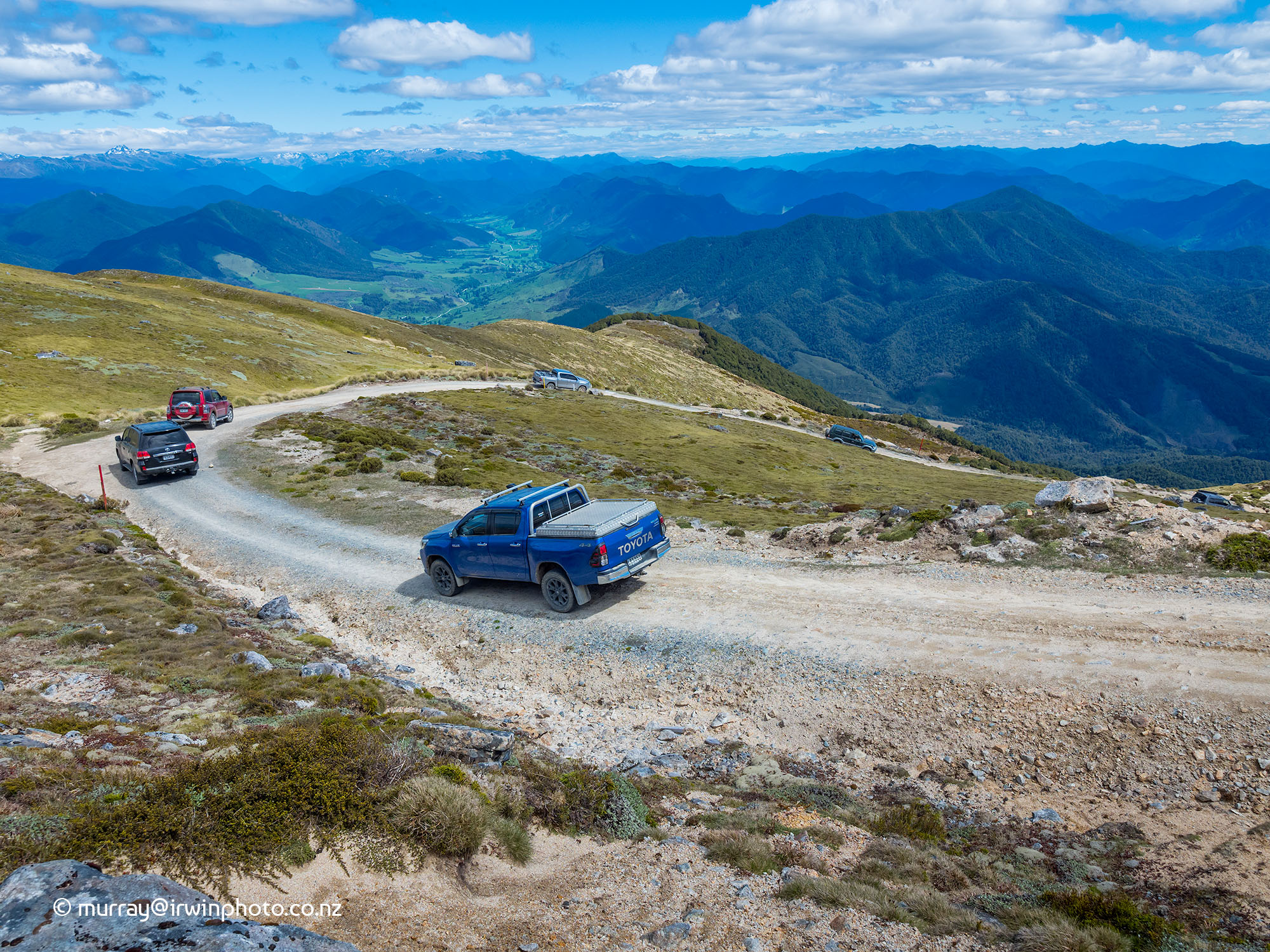
Shortly our column of fourteen vehicles left Jacks Pass Road and turned into Clarence Valley Road, driving over Jacks Pass before dropping into the Clarence River Valley and meandering north along the Tophouse Road, also known as the Rainbow Road. This 112 kilometre long mainly gravel road connecting Hanmer Springs, Canterbury, in the south with St Arnaud, Nelson Province, in the north was constructed in the 1950s to facilitate the installation of a power pylon line to deliver power to Nelson and Buller regions. The Clarence River in its upper reaches here forms the boundary between the Molesworth and St James Conservation areas.
Our first stop was to view the historic Fowlers Hut. Described by one visitor as ‘No bunks, no fire, unlined, very cold - warmer outside in my experience.’ This modest dwelling was built in the early 1890s to house a caretaker of the rabbit proof fence between Canterbury and Nelson.
Next stop at a car park beside the Clarence River was a comfort stop before tackling the 4WD track over the Mailing Pass (1308 metres ASL). About five or six vehicles made it over the pass before our guide decided the track condition was unsuitable. Returning to the car park we crossed the Clarence River for the last time and proceeded to our lunch stop at Lake Tennyson DOC campsite.
After lunch we climbed up and over Island Saddle, claimed to be the highest publicly accessible road in new Zealand at 1347 metres ASL. In doing this we crossed from the catchment of the Clarence River to the catchment of the Wairau River which we were soon travelling beside.
The Rainbow Road to Lake Tennyson from Hanmer Springs is passable in a two wheel drive vehicle, but beyond that it DOC advises ‘a high-clearance 4WD is required to negotiate the road’.
After several rough fords we encountered what appeared to be two impassable deep washed out channels in mobile scree fans. One with a vertical face of over a metre and a half up, to which we needed to raise fourteen heavy 4WD vehicles. However an hour of determined repositioning of rocks and gravel under expert guidance and all our vehicles were on their way north again.
From there the remainder of the journey was fairly straight forward. After stopping at St Arnaud to view Lake Rotoiti and the tame Eels under the jetty it was 60 kilometres on sealed roads to our destination for the night, Murchison.
Day two.
Having completed radio check at 8:00am our first point of interest was the remaining structures and equipment of the Six Mile power station up the Matakitaki Valley to the south of Murchison. Opened in 1922 to much fanfare in Murchison it served the power needs of the local community for nearly 54 years before being shut down in 1975.
There is an easy walk of one and a half hours return which follows the old water collection and storage facilities to the weir which diverted water from Six Mile Creek into the hydro power scheme. None of our party took the opportunity to enjoy this walk but we did in February 2020.
A Six Mile local with a sense of humour. I like this sign.
Returning to Murchison our convoy turned right onto State Highway 6 for 4.3 kilometres before turning right onto the Mangles Valley Road. After about thirteen kilometres we turned left at Tutaki and followed a well formed gravel road through Beech forest to Lake Rotoroa for morning tea. This easy route is known as the Braeburn Track.
Leaving Lake Rotoroa behind we travelled down Gowan Valley Road to Gowan Bridge. Turning right towards Kawatiri where we turned down the St Arnaud Kawatiri Highway for about nine kilometres then right onto the Howard Valley Road and a further five kilometres to the start of the Porika Track. This sixteen kilometre long track follows old stock routes that historically serviced gold and timber extraction in the area. It passes through the New Creek gold fossicking area. The climb on the Howard Valley side was fairly straight forward apart from a forty metre section of deep wet clay mud on an incline. All of our convoy vehicles passed this obstacle on their own.
The descent on the Lake Rotoroa side offered occasional spectacular views but was rutted and rocky with tight zig zags as we negotiated our way slowly and carefully to our lunch stop back at Lake Rotoroa again.
With lunch completed we travelled back along State Highway 6 until we were one kilometre west of the Owen River bridge. Here we turned off highway 6 onto Rait Road and crossed the bridge over the Buller River. Soon after this we started the steep 1100 metre ascent to the top of Mount Murchison. Arriving at the summit of this mountain 1469 metres ASL we were at the highest point of our five day tour and the views were epic with weather to match. Simply stunning.
This was the last planned activity for day two of our tour after which we departed for the long descent and returned to our accommodation in Murchison for a well earned drink in the late afternoon sun.
Day three.
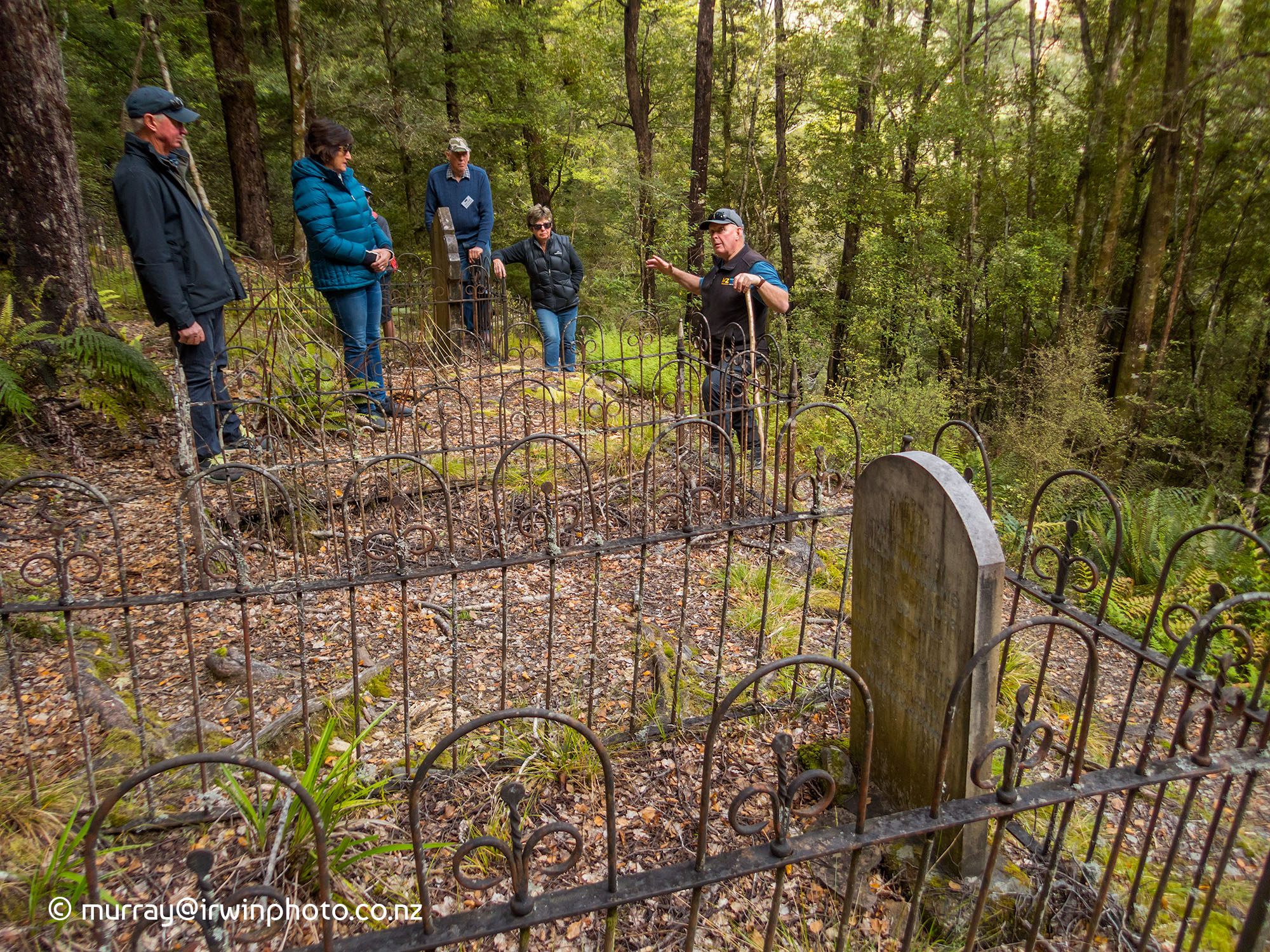
On our way again after breakfast and the 8:00 am radio check, we followed the course of the Buller River west to our first point of interest, the site of the deserted historic gold mining town of Lyell. In particular, the Lyell cemetery perched on the side of a steep hill above the town site. This was necessary as flat building land was at a premium for the town of three thousand inhabitants.
Next on our itinerary was the overland track from Iron Bridge to Denniston, but uncertainty regarding the crossing of the Mackley River convinced our guide Robbie to abandon this trip and head directly to Denniston and the Dennison Plateau. Here we explored some of the extensive network of rough and rocky tracks on this bleak, coal bearing plateau.
Our day was wrapped up with a visit to the historic DOC managed site of the Denniston coal mine coal handling facilities and the Denniston incline. The incline was a very steep cable railway down which all the mined coal travelled to the bottom of the hill for distribution by road or railway. The endless cable used the weight of the descending full wagons to pull the empty wagons back up to the loading facilities at the top. Relics restored by DOC and information boards made this a worthwhile stop.
After driving down from the plateau we had a short drive to our accommodation for the night at the town of Westport at the mouth of the Buller River.
Day four.
Our intended 4WD drive activity for day four was to drive to Reefton then to the Big River Track to the Big River gold mine. Unfortunately six metres of the 4WD track has been completely washed out making it totally impassible.
Plan B was a different type of 4WD drive experience travelling by Unimog for a guided tour of the Stockton open cast coal mine. This five hour tour was most interesting especially the extent of effort that is applied to protecting the fauna and flora and the rehabilitation of the landscape once the coal has been removed.
After the rehabilitation process is completed it is virtually impossible to distinguish the rehabilitated land from the natural untouched landscape. The process is accelerated by the application of treated Bio-Solids from the Christchurch waste water treatment plant.
At the completion of our Stockton Mine tour in Westport our convoy drove back up the Buller River Gorge to Inangahua and then to Reefton for the night.
Day five.
Under way again on our last day of our West Coast Explorer Tour with nzadventures.co.nz
As we reached Ahaura in the Grey River Valley we turned east onto the Ahaura Kopara Road for 8.5 kilometres before a left turn onto Orwell Creek Road. Proceeding to the end of the road we were met by the Smith family who have spent around twenty five years converting their property from two metre high Gorse and scrub to the lush open pasture land surrounding their lovely self built home that we saw.

After a brief presentation of the history of their land and Orwell Creek we were shown to a tunnel about 100 metres in length that the Smith’s believe was cut to divert water for gold mining activities. Another interesting feature of this tunnel was the large Wetas that lived in the very dark environment. Following this we were also shown another gold mining relic which was a deep vertical cut in the hillside near their home. Lined with ferns and other plants clinging to the damp walls, this was a cool peaceful place with a seat to enjoy the solitude. From there it was back to the farmhouse for fresh scones and pikelets with cream and jam.
One outstanding feature of the property was the large water wheel, which along with a few solar panels, satisfied the entire electricity needs for the Smith’s home. The water wheel turns the motor from an old Gentle Annie washing machine which then acts as a generator. Very ingenious.
Well satisfied with scones and pikelets we returned to our vehicles and drove to the top of the Smith’s farm where we entered the DOC reserve of Napoleon Hill. Not long after we entered the reserve we came to a clear mossy area surrounded by a few weathered fence posts and barbed wire. This was the Napoleon Hill cemetery and is all that remains of the 19th century gold mining town of Napoleon Hill.
From here it was a long slow descent down the steep and at times demanding track to Noble Creek where we travelled along the creek bed in the Noble Creek gorge.
The stand out feature of this 4WD track are the tunnels cut by gold miners to divert the water flow allowing the miners to mine the dried out creek beds. We were easily able to drive our vehicles through two of these tunnels. Seriously cool.
Following lunch at the exit from the last tunnel we entered the Waipuna Creek and drove down the creek bed to leave the creek at the Waipuna Road bridge. This marked the end of our four wheel driving for this tour. Our accommodation for the night was at Greymouth and after breakfast the following morning we returned home to Christchurch. A round trip of 1295 kilometres.