10/02/2022
After a brief trip into Ashburton we returned travelling on to Mount Somers township. A resident on the Ashburton Staveley Road with a sense of humour has constructed a rather impressive and novel letterbox which put a smile on our faces.
Beyond Mount Somers we proceeded through the Ashburton River gorge into the
Hakatere Conservation Park and Lake Clearwater where we walked part of the walking track around the lake in beautiful sunny conditions with warm north west winds.
We parked for the night at Lake Camp which lies close alongside Lake Clearwater with a large bach community between them.
The view across the lake to the alpine tussock land was stunning.
11/02/2022
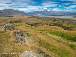
Travelling further along the road to the Rangitata River basin and the Mount Sunday walking track. This small hill earned it’s name as the place where boundary riders from the surrounding high country stations would meet on Sundays. We also discovered that it was used as a movie site for one of the scenes in The Lord of the Rings, The Two Towers, named Edoras.
The views from the top of Mount Sunday of the Rangitata River basin and surrounding mountains are expansive and breath taking.
And snow capped ranges beyond Erewhon high country station.

12/02/2022
As well as providing parking and facilities for camper vans, motorhomes and caravans, Clent Hills Station offers accommodation in a delightful collection of restored, renovated farm buildings and contemporary Pods.
Other rustic old farm buildings create a real rural atmosphere which we thoroughly enjoyed.
Departing Clent Hills we proceeded to Lake Heron to take in more of this wilderness area and a bit of fishing.
Leaving the Hakatere Conservation Park after a brief stop at the historic Hakatere Station stone cottage originally constructed in 1862, the heavy cloud turned to rain.
Having experienced the Hakatere Conservation Park and Ashburton Lakes district we are left with a lasting impression of the of the sheer vastness of this network of connected valleys and surrounding mountains. This is truly BIG country.
13/02/2022
After rain all night, today was a Pleasant day, despite dull overcast weather with showers and drizzle all day.
We started the day at Pleasant Valley Hall. A century old community meeting place and function centre from an era when architecture was functional and corrugated iron was an acceptably fashionable cladding. For us, it was a gravel car park free of mud with internet and cellphone reception.
We finished our day at Pleasant Point Domain campground with the promise of better weather tomorrow. That was about it for the day with swollen rivers and sodden muddy camping grounds at Te Moana Gorge and
Pioneer Park not suitable for us to spend the night.
Pleasant Point Domain is home to a small colony of New Zealand Long Tailed Bats which live in a small of number of the trees surrounding the golf course.
14/02/2022
Considering the weather forecast for the Mackenzie Basin was superb today, we decided to leave South Canterbury and head towards Tekapo, with one or two stops along the way. First stop was O’Neill’s Reserve near Cave, which was another option for our next stop. However the Tengawai River was still running high and discoloured, which was a shame as this campsite is a favourite of ours.
Onward to be shortly confronted by the view of fresh snow in front of us on the Ranges to the West of Fairlie, framed by the main street.
Ah well, nothing for it but to sample one of the renowned Fairlie Pies. Very good pies, well worth stopping for. We reckon they are an 8/10.
Next was
Three Creeks at Burkes Pass township. A quirky Arts, Crafts and memorabilia shop surrounded by fantastic memorabilia displays, classic cars and trucks plus much more. Hard to take it all in.
Over Burkes Pass and into the Mackenzie Basin. We are reminded of the vast, barren, waste land that is characteristic of a large part of this area.
After arriving at the NZMCA Tekapo campsite we walked along the shoreline of Lake Tekapo which is adjacent to the camp site. The distinctive turquoise colour of this glacier fed lake is due to the presence of Rock Flour in the water, created by the glaciers grinding the bed rock beneath them.

15/02/2022
Just a short trip today to re-visit another very pretty camp site we enjoy, Lake McGregor. This picturesque small lake sits alongside Lake Alexandrina with a large bach and caravan community between them. Both lakes are popular with anglers.
On our way to Lake McGregor we stopped to wander round the Tekapo Peninsula Walkway. Offering great views of Lake Tekapo and the surrounding mountains, this is an easy 4 kilometre walk. We were astonished by the number of rabbits on this land. Having seen hundreds of them ourselves we can only conclude that there must be thousands of them infesting this piece of land.
Following our walk we spent the rest of the day at Lake McGregor enjoying the sunny weather.


16/02/2022
Left Lake McGregor today bound for a campsite we haven’t stayed at before as it has usually been very full. Lake Wardell is just south of Lake Pukaki right alongside the Pukaki hydro canal which makes it very popular with anglers hoping to catch the massive trout and salmon that reside in the canal system. But first an obligatory photograph of Mount Cook across the turquoise water of Lake Pukaki.
Next we donned our walking shoes to tackle the Pukaki Kettle Hole walking track. This easy 4 kilometre track takes you across the glacial moraine mound left behind by the Tasman Glacier as it retreated 14000 years ago. Leaving a huge block of ice behind, covered in gravel which insulated it from the sun, as the glacier retreated. This block of ice slowly melted over a long period of time leaving the large hole visible in the moraine mound. The Tasman Glacier terminated at about this point 20000 years ago, where it was 300 metres deep and 85 kilometres long.
Arriving at Lake Wardell, which is rather on the small side to be called a lake, but very pretty, we settled in for the night. Another enjoyable day in great weather.

17/02/2022 – 19/02/2022
We plan to return to Mount Cook National Park to enjoy this special alpine environment without the unsustainable numbers of tourists we encountered three years ago, pre-COVID. To get the best experience we need a window of clear, fine, weather so hopefully the mountain tops are free of cloud. To achieve this we needed to wait for three days to allow an adverse forecast weather system to pass through.
Leaving Lake Wardell, a journey of a mere two kilometres brought us to Lake Poaka Campsite, where we paused for two days to allow the weather to settle. This lake is similar to Lake Wardell but much larger. Situated next to the Pukaki hydro canal with ample parking and very pleasant views, walking, swimming, fishing or just relaxing are options for passing the time.
Photographing the stunning sunsets and sunrises proved too much of a temptation. To easy.
If you wake up early enough you might even photograph the sun rising in the east and the full moon setting in the west.
The Department of Conservation are enhancing this campsite by removing extensive invasive exotic trees and shrubs which have choked the far side of the lake. Good work DOC!
20/02/2022
Having spent the night at Twizel to re-provision our motorhome, we made an early start on our drive to Aoraki, Mount Cook. Arriving at the DOC campsite at White Horse Hill in brilliant sunny weather we were pleasantly surprised by the low number of visitors and vehicles compared with our experience three years earlier.
Eager to make the most of our two day campsite booking, we promptly walked to Kea Point, where as was the case three years earlier, there were no Keas. Sitting in the sunshine taking in the atmosphere we could hear the creaking and groaning of the ice falls on Mount Sefton towering above us, along with the occasional roar of rock slides and avalanches.
Following that we walked to the Mueller Glacier terminal lake view point and the commemorative monument to all the souls who have lost their lives on the surrounding mountains.
Very hazy conditions masked the views of Mount Cook and Mount Sefton, conditions not conducive for photography.

21/02/2022
The rising sun put on a dramatic lighting display on Mount Sefton as the day dawned fine and sunny.
First priority for today was walking to the Hooker Glacier terminal lake at the base of Mount Cook with plenty to photograph on the way. This three hour return track takes you past the Mueller Glacier terminal lake, over three large swing bridges with mud coloured melt water swirling below, and past majestic alpine scenery to the iceberg laden Hooker Lake.
Our afternoon excursion was to the Tasman Glacier view point from where the base of the glacier, New Zealand’s longest at 23 kilometres, can be seen at a distance.
The viewing point is atop a moraine mound about one hundred metres high, of large jagged rocks left by the retreating glacier.
As we started our return to the campsite the first gusts of a strengthening nor’wester made us hang onto our hats. A truly exceptional day without hundreds of tourists detracting from the experience of this remarkable alpine wilderness.
This was a return visit as one of our most enjoyable places on our tour three years previous and it lived up to expectation and beyond.
Our 2019 Aoraki, Mount Cook post.
22/02/22
After an uncomfortable night due to our motorhome being shaken strongly by a fresh gusty nor’westerly wind we were happy to make an early departure from Aoraki, Mount Cook. All in all this side trip was a great success from our perspective.
There are very few places in New Zealand where such magnificent alpine scenery on such a grand scale is as easily accessible as Aoraki, Mount Cook. This experience should be on every Kiwis ‘Bucket List’.
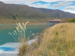
With time up our sleeves we decided to visit the Haldon Arm of Lake Benmore. This part of the lake is most easily accessed where the Ohau hydro canal flows into the lake after passing through Ohau C power station. A very pleasant destination, especially for anglers, with two campgrounds, it is worth revisiting.
However, our intention was to travel on to Lake Ohau to stay at the DOC campsite at Lake Middleton which lies right alongside Lake Ohau, at Ohau village. We spent a night here on our 2019 journey which we enjoyed. Unfortunately many of the large coniferous trees that gave this camp much of its appeal and shelter from the wind, have been removed.

23/02/2022
Another windy night due to a cold southerly front passing through, which thankfully wasn’t as uncomfortable as the previous night.
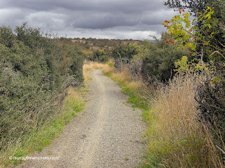
With no particular plan for today we drove further up Lake Ohau to Round Bush DOC campground but decided it was it bit exposed to the wind. After a rethink we headed for the Lake Ohau walking track which skirts the southern end of the lake. This turned out to be a tedious affair weaving through an assortment of native and exotic scrubs, most with thorns or spikes, generally obscuring the view of the lake.
After about five kilometres, we decided to return to our vehicle and back to lake Middleton camp for another night. This uninteresting walkway also serves as part of the Te Araroa Trail and the Alps 2 Ocean Cycle Trail from Mount Cook to Oamaru.
Probably best done on your bike or not at all.
Update April 2023
Revisiting Lake Middleton for a couple of nights our interest was raised by the Freehold Creek Track on the glacial moraine terraces high above Lake Ohau. Rising steadily through Beech forest from the start of the track at the car park on the shore of Lake Ohau, it soon reaches the terraces which provide easy walking through open tussock country on a gentle incline. It is recommended not to proceed beyond the Freehold Creek bridge as the track becomes very demanding from this point on. The 7.5 kilometres that we walked to the bridge and back took us a leisurely 2 hours with spectacular views all round. A great walk.


24/02/2022
Plan for today first up was to walk the DOC Wairepo Kettleholes Track. So off we went to find the starting point. This track took us two and a half kilometres along sparsely marked farm easement roads to a style over a fence with no further indication of where to go to find the Wairepo Kettleholes. After following a fence line through tussocks, Matagouri and thistles for over a kilometre we came across three swampy areas which on consultation with Google Maps proved to be the Kettleholes.
Fortunately a kind farmer transported us from the style back to our vehicle, saving us two and a half kilometres wear on our shoes. This walking track proved to be a once in a life time walk.
Do it once and you’ll never want to do it again.
This uninteresting, poorly marked or maintained track, claimed to be three kilometres return, took us a total of seven and a half kilometres by foot and vehicle.
Save yourself three hours of your life. Don’t bother!
Onward to Lake Benmore for some fishing and Otematata for the night.
25/02/2022
After our previous two days walking track fails we were a little circumspect about our choice of exploration on foot. The Benmore Peninsula Track, starting at a car park above the Benmore hydro electric dam should be a good choice. However, less than clear instructions and track markers resulted in us completing the circuit partly on the track and partly on forestry access roads. We got back to our motorhome with great views of the Benmore Dam recorded in our trusty camera. Spectacular!
Proceeding further down the Waitaki River valley along the eastern shore of Lake Aviemore brought us to the Deep Stream walking track. This flooded canyon formed by the filling of the lake behind Aviemore Dam is beautiful as shown in our photographs.
Passing the last and oldest hydro electric dam on the Waitaki Electricity Scheme, Waitaki Dam (completed in 1935), we travelled to Bortons Pond in the Lower Waitaki Valley for the night.
An interesting thought that by the time water originating at Lake Tekapo leaves the Waitaki Hydro Electric Dam it has passed through nine generating turbines on its journey to the Pacific Ocean.
Update April 2023
We returned to Deep Stream with our inflatable canoe, and despite the discoloured water due to recent heavy rain, paddling through this imposing steep sided canyon was just as memorable as it had been on our previous visits on foot.
26/02/2022
Nothing much to report today. Bortons Pond through Oamaru to Glencoe Scenic Reserve Campsite, about 2 kilometres west of Herbert. A very pleasant campsite, tidy and well maintained amid native bush alongside the Waianakarua River. Well done DOC.


27/02/2022
A busy day today after leaving Glencoe Scenic Reserve we turned off State Highway One at Hampden to go to Hampden Beach which had been recommended to us. A lovely beach as had been reported to us, so we walked along the beach for a while in the direction of Moeraki and it’s famous boulders. There were a few of these concretion boulders scattered along Hampden beach as well. After our beach walk we were able to relax on a wooden sofa, which has been artfully crafted with a chain saw from a huge Macrocarpa tree stump.
We had resolved to have a good look at the Otago Peninsula, which we usually bypass, starting with the north side. Leaving State Highway again at Waitati our first destination was Long Beach, where we walked on this beautiful white sand beach surrounded by the steep hills of ancient volcanic origin that form the peninsula.
The roads along the high ridges provide spectacular views, but are narrow and twisty making stopping to admire the views or take photographs difficult. Our route brought us down to Otago Harbour at Port Chalmers which caters to large container, log and cruise ships that can’t navigate the channel to Port Dunedin about ten kilometres further up this narrow harbour.
To finish the afternoon we strolled about ten kilometres total out and back along the Dunedin Harbourside Walkway / Cycleway. This purpose built facility is a real asset to Dunedin, and being right on the harbour foreshore for much of it’s length, is most enjoyable.


28/02/2022
In keeping with our commitment to explore the Otago Peninsula on this journey, we set out for the southern side of the peninsula, travelling along the Portobello Road which follows the southern and eastern side of Otago Harbour alongside an excellent walkway / cycleway. This route took us first to Taiaroa Head Nature Reserve at the harbour entrance, famous as the only mainland nesting colony of the Northern Royal Albatross. We were treated to spectacular views up the harbour, of the rugged coastline and the lighthouse as albatrosses soared overhead. Truly magnificent animals. The DOC information centre is very informative as well.


Moving on, we traversed the peninsula with expansive views of Otago Harbour and Dunedin on one side and beautiful bays and beaches on the ocean side. As with yesterday, the roads were very windy, narrow and steep, allowing us limited opportunities to stop. Our motorhome is possibly not the most suitable vehicle for this excursion. Eventually we arrived at Tomahawk Beach where we took a walk and some sea air along the white sand beach. The beaches of Otago continue to captivate us with their beauty. From Tomahawk Beach we finished our day with family in Sawyers Bay, where we spent the night parked on their driveway.


wise idea guys to stay close to home but enjoy the experience
ReplyDeleteYou haven't lost your photographic touch Muz. Pictures are superb and enjoying the descriptions and explanations of the features. Safe travels.L
ReplyDeletelooks a great trip so far. lots of fantastic photo's. well done! si
ReplyDelete