The walk up the 4 wheel drive access road provided wide views across the Pupu and Takaka valleys towards Ligar Bay and Tata Beach plus the bonus of a few Rata flowers in bloom.


06/04/2021
Our intention for the next few days was to explore what Golden Bay has to offer north of Takaka starting with the Aorere valley. But first, the words 'derelict wharf' on the topographic map at Onekaka estuary were too much to resist. Parking our motorhome, we proceeded to the beach only to find the Onekaka wharf is truly derelict, consisting of a few well rusted iron wharf piles. This heritage listed structure is all that is left of the wharf and tramline that served a large ironworks manufacturing pig iron and pipes in the 1920s, using Limonite mined locally. From 1929 electricity generated at the Pupu power station was used in the production of pipes. However, the ironworks proved to be uneconomic compared to overseas production and ceased operation in 1935.
Moving on, we briefly stopped at Parapara beach which is a desirable beach side collection of homes and baches.
Entering the Aorere valley we drove to Rockville where we found the 'Devils Boots'. These large limestone formations rest either side of the road and have been eroded to look like two gigantic boots buried upside down in the earth.
Further up the Aorere valley we stopped at Salisbury Bridge and falls, the site of a historic foot bridge that was constructed originally in 1882 to allow gold miners access to the south side of the Aorere river. It has been swept away twice by massive floods in 1899 and finally in 2010 by flood waters that filled the gorge to a depth of 13.75 metres. All that remains next to the road bridge are the suspension support frames and suspension cable anchors. Today the deep narrow gorge is a popular swimming spot and public gold fossicking area.
Reaching the end of the Aorere valley road brought us to the northern end of the Heaphy Track and the Brown river hut. Here we walked about three kilometres along the track before returning to spend the night beside the Aorere River.


07/04/2021
On our return back down the valley we had brief glimpses of a tranquil looking Aorere River as we made our way to The Langford Store at Bainham.
Visiting The Langford Store is like being transported back in time to the middle of last century. Opened in 1928, it has been in the Langford family for four generations and is packed with antiques and curios. There is a lot of nostalgia here particularly if you are a Baby Boomer or older. Hot drinks and sweet treats can be purchased and there is a gallery displaying local artists work. Coffee with scones, fresh cream and raspberry jam consumed while sitting in the sun, perfect.
Back to Rockville, then past the Devils Boots again to the start of the
Aorere Goldfields Track. This walk of about three to four hours takes in some of the more accessible remnants of gold mining in this area including an old ground-sluicing claim worked in the 1880s, walking along part of the original miners benched access track beside an old disused water race and Druggan's Dam and reservoir.
Other features along this walk are the occasional excellent views of the Wakamarama and Burnett ranges, Ruataniwha Inlet and north to Farewell Spit. Plus Stafford's and Ballroom caves which can be explored with a torch. The Ballroom cave is particularly worth the effort as it is large with stalagmite and stalactite formations. It is reported that the miners used this cave as a venue for dances, hence it's name.


08/04/2021
We spent the night at Collingwood Holiday Park on the banks of the Aorere river lagoon ready to board our guided tour out on Farewell Spit. We have never been on the spit before so this was another bucket list tick box. It was a wonderful experience travelling in a comfortable four wheel drive bus with an interesting commentary by the driver. Planned stops to get out of the bus and walk on Farewell Spit started at Fossil Beach at the very start of the long sandy beach of the spit, later at the light house 27 kilometres along the spit and finally on the dunes about halfway back.
It is hard to describe how vast and desolate Farewell Spit is, but I hope our photographs help to convey this.
After we left Farewell Spit we were taken to the windswept cliffs of Cape Farewell, the northern most point on the mainland of the South Island. About this time two years ago we were standing on the southern most point of the mainland of the South Island, Slope Point.
You may have noticed the base of the lighthouse legs painted red. We were told that this happened in 1995 when Team New Zealand won the America's Cup for the first time while Sir Peter Blake was wearing his lucky red socks and the nation responded in kind.
A fantastic day!

09/04/2021 - 12/04/2021
After having spent two days hunkered down waiting for very heavy rain and gale force winds to pass by we positioned ourselves at Pakawau Beach Camp ready to make our next excursion. A small window of improved weather was forecast so we crossed the low saddle to Whanganui Inlet on the west coast of Golden Bay.
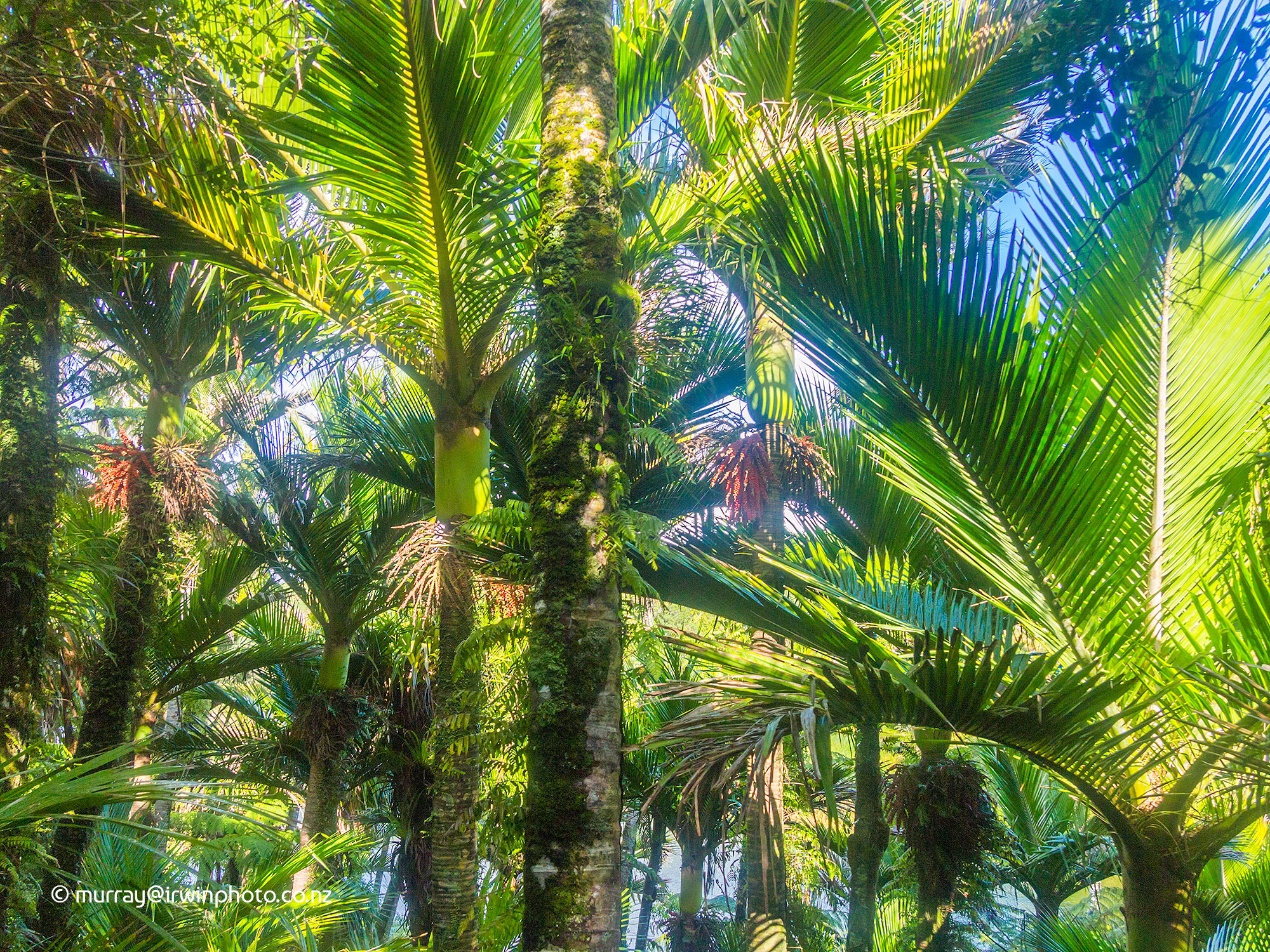
On reaching the inlet we took a side trip to Kaihoka Lakes. These two lakes, a ten minute walk apart, are the result of ancient sandhills advancing in the prevailing westerly winds, blocking the flow of water from land to sea, subsequently forming lakes in the depressions left between the sand hills and the gullies they blocked. In fact, most of the hills in this area are on closer inspection are very large sand dunes that have been over grown by grasses, scrub and forest. The lakes are surrounded by native bush reserve with particularly lush and abundant Nikau Palms.
Travelling on around the eastern side of Whanganui Inlet the road crosses beautiful inlets by numerous causeways and many kilometres of winding gravel road.
Our final stop for the day was the Anatori River mouth, a very remote location beyond which a four wheel drive vehicle is required to cross the river to travel the last few kilometres to the road end at the Turimawiwi River, in sight of Kahurangi Point to the south. We spent the night in the bush camp beside the swollen Anatori River with the sound of the huge surf pounding on the nearby beach.
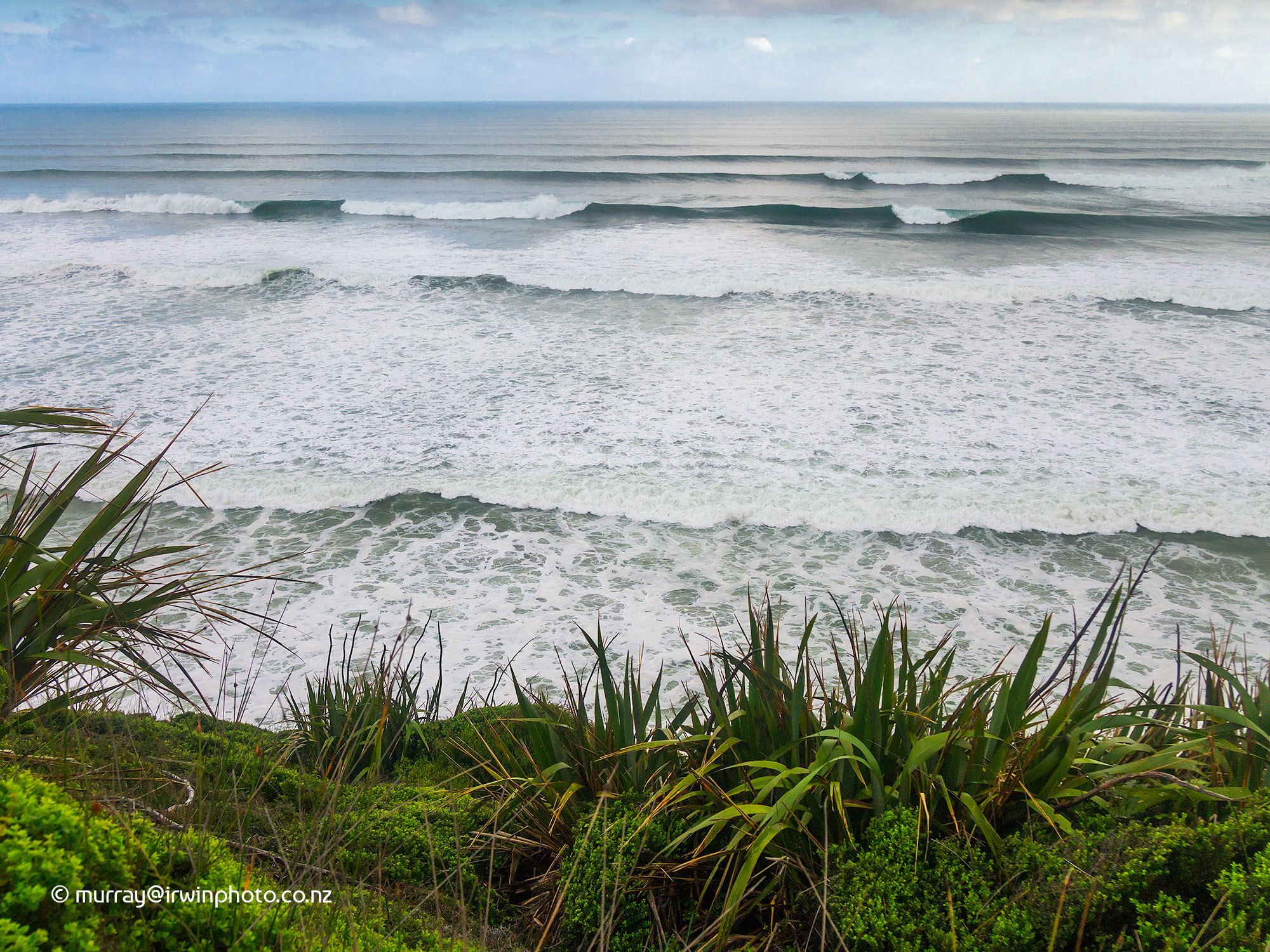
After a morning walk up the Kokopu River, a tributary of the Anatori River, and down to the Anatori River mouth, we started the return journey back along the rough, winding gravel road that had lead us there the day before. Despite the gloomy weather the views were spectacular, dominated by the huge surf which is common on the west coast beaches of the South Island. We estimated the breaking waves about four hundred metres offshore were around five metres high.
On our return journey we stopped at the Paturau River mouth with it's camping area at the beach head and rather to the point sign. Surrounded by imposing steep hills covered with weathered rock outcrops, we had intended staying here for the night. But given the forecast of deteriorating weather with gale force winds, this exposed camp site was not the place to stay, so we continued on our way.
Upon reaching Mangarakau we stopped to look at the Mangarakau swamp. This is an area of natural beauty being restored and maintained by the Department of Conservation and a team of volunteers. At 350 hectares it is the largest freshwater wetland in the South Island and part of only ten percent of remaining original freshwater wetlands in New Zealand. There is a visitor centre, walking tracks and look outs for viewing the lakes and the swamp vegetation and wild life.


One other place of interest at which we stopped on our forty four kilometre return journey from Anatori to Pakawau was the dilapidated Mangarakau fishing wharf with the remains of the old scow Kohi laying alongside. The scow Kohi, built in 1911, was retired from the coastal shipping trade in 1966 after which a group of fishermen towed it to Whanganui Inlet alongside Mangarakau wharf to serve as a Crayfish processing plant with a freezer installed on the fore deck. Here she still lies today laying in the mud rotting. With more inclement weather forecast we returned to Takaka.


It had been our intention following Whanganui Inlet and Anatori to continue north to Wharariki Beach with it's monolithic rock formations standing in the surf like enormous prehistoric animals. Here there is a network of walking tracks to the beach and Puponga via Cape Farewell and Pillar Point lighthouse where great views of Farewell Spit can be enjoyed. Due to the adverse weather situation we left this excellent natural attraction off our adventure this time around. We have explored Wharariki Beach and surrounds several times in the past and we have posted photographs from a previous visit.
Don't miss this experience if you are in Golden Bay.
After three more days of indifferent weather we decided our time in Golden Bay was over for this trip. After farewelling our family we were on our way to Nelson for more time with friends and the start of our journey home. However, any visit to Golden Bay is not complete without seeing one of the major attractions, the Te Waikoropupu Springs. This is the largest fresh water springs in New Zealand and the largest cold water springs in the southern hemisphere, discharging 14,000 litres per second at a constant 11.7 degrees celcius. Accessed by a short walk, these springs are renowned for their blue colour and water clarity which is one of the highest measured anywhere.
Our final activity as we departed Golden Bay was walking the Takaka Hill Walkway. This loop track climbs from the Takaka Hill Saddle at 790 metres above sea level to 950 masl and offers wide views of Golden Bay to Farewell Spit, Tasman Bay to D'urville Island and vast areas of fascinating Karst landscape. Karst is formed by the dissolution of the limestone rocks by water over a long period and has resulted in the large areas of sculptured and shattered rocks.